Lamphey and Hodgeston are ancient parishes.
The present day Community is Lamphey with Hodgeston. The coast forms the southern
boundary of Lamphey and Hodgeston.
The name Lamphey probably goes back to the
time when pioneering preachers were endeavouring to Christianise the area. According
to tradition one of these was Tyfai, said to have been a nephew of the very
influential Teilo who founded a 'llan' or church here. The name 'Llantefei'
occurs in the 12th century, with later variants.
Hodgeston was probably the farm of someone
called Hogge or Hodge, a by-form of the Continental personal name Roger (B G
Charles, Place Names of Pembrokeshire) and it dates from the Norman period.
Back
to top
The earliest human activity locally was tool
making in the Mesolithic period (between 10,000 and 6,000 years ago) and the
early Neolithic period which followed. The flint-working floors were mainly
around Freshwater Bay, but there have been finds also at Hodgeston Hill and
elsewhere. Traces of a prehistoric hearth and cooking place were identified
also at Hodgeston Hall, with the possibility of another where Lamphey Lodge
now stands.
Above Freshwater is an earthwork probably of
the Iron Age. Amongst the Iron Age people were Celtic speakers who eventually
evolved into the Welsh, and it was to them that people like Tyfai preached in
the early Christian period.
Back
to top
Amongst remains in the landscape is evidence
of a moated homestead at Hodgeston. This is a square site with the earthworks
of the surrounding moat still visible. Hodgeston was a knight's fee in the Barony
of Manorbier and Earldom of Pembroke (according to Brian Howells on whom our
study of the locality in the Middle Ages depends). Documentary references show
that several present day homesteads existed in medieval times.
 At Little Portclew (Porthlliw) there was a chapel adjoining a spring; possibly
this was venerated, and hence the building of a chapel. The two parish churches
were present as today. But most important of all the local medieval features
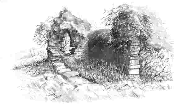
is the Bishop's Palace - for which there is a Cadw guide. The surviving masonry
on this very attractive site spans three centuries and includes remnants of
three halls, the first largely ruinous. The second (13th century) retains noteworthy
features. Henry de Gower who became bishop in 1328 was responsible for the third
and associated buildings. The chapel was re-modelled in the early 16th century
and in Elizabethan times certain domestic features were updated by the Devereux
family (see Sian Rees, A Guide to Ancient and Historic Wales: Dyfed).
At Little Portclew (Porthlliw) there was a chapel adjoining a spring; possibly
this was venerated, and hence the building of a chapel. The two parish churches
were present as today. But most important of all the local medieval features
is the Bishop's Palace - for which there is a Cadw guide. The surviving masonry
on this very attractive site spans three centuries and includes remnants of
three halls, the first largely ruinous. The second (13th century) retains noteworthy
features. Henry de Gower who became bishop in 1328 was responsible for the third
and associated buildings. The chapel was re-modelled in the early 16th century
and in Elizabethan times certain domestic features were updated by the Devereux
family (see Sian Rees, A Guide to Ancient and Historic Wales: Dyfed).
Back
to top
 Lamphey stands out amongst villages for its connections with the important and
famous and for its high status residences. It gained a particular aura in the
Middle Ages as one of the manors of the Bishops of St Davids and the location
of one of their palaces. Who donated the land to the See of St Davids and when
is unknown. It seems likely to have been a Welsh landowner since there was already
an episcopal residence here in 1096, just 30 years after the Norman arrival in
England.
Lamphey stands out amongst villages for its connections with the important and
famous and for its high status residences. It gained a particular aura in the
Middle Ages as one of the manors of the Bishops of St Davids and the location
of one of their palaces. Who donated the land to the See of St Davids and when
is unknown. It seems likely to have been a Welsh landowner since there was already
an episcopal residence here in 1096, just 30 years after the Norman arrival in
England.
A survey of the bishop's properties made in
1326 and known as 'The Black Book of St Davids' includes Lamphey, with its four
fishponds, a dovecot, two watermills and one windmill. Some of the well known
features of the locality are a reminder of this time: (Lamphey) Park - the bishop's
deer park and Bishop's Meadow. The word Callands appears in the survey as 'Kalenge',
the rather puzzling name of one of the open fields (perhaps 'land in dispute'
at some time unknown).
Lamphey ceased to be a residence of the bishops
in the upheavals of King Henry VIII's reign resulting from the break with Rome
and royal autocracy. Many church estates fell into the hands of the Crown and
most were re-granted to secular holders. Amongst these was Lamphey, granted
to Richard Devereux son of one of Henry VIII's trusted servants.
Back
to top
The first secular holders of the manor in modern
times were members of the Devereux family. Walter Devereux of Lamphey was created
earl of Essex in 1572, but died in 1576. His brother George Devereux lived at
Lamphey until about 1597. Robert the second earl spent much of his youth here
in the household of his uncle, but in 1584 departed for the court of Queen Elizabeth.
His ambitions led him to disaster: a failed uprising in 1601 and execution.
For a time the Devereux fortunes were eclipsed but in due course Earl Robert's
son was allowed to inherit his father's titles and estates. He, the third Earl,
was the leading Parliamentary Commander in the first stage of the Civil War
of the seventeenth century.
At that time Lamphey Palace was occupied by
a tenant. Lamphey Palace and Estate were sold in 1683 to Sir Hugh Owen of Orielton
(ancient parish of Monkton). The property remained with that family until about
1822, when it was sold to Charles Delamotte Mathias of Llangwarren in North
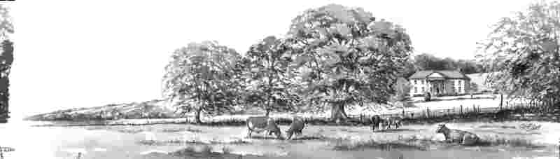
Pembrokeshire. For over a century and a half, the Mathiases were the dominant
influence at Lamphey. The new Lamphey Court, built in 1823, was their seat until
sold by Wing Commander Mathias in 1978.
Back
to top
Lamphey lies on the ancient ridge route between
Tenby and Pembroke and near the waters of Milford Haven. It is said that at
high water goods could be brought up from Pembroke to the mill (near Northdown
Bridge), and then punted up to the Court itself . In the 19th century, road
improvements and the construction of the Pembroke and Tenby Railway (linked
in due course to the wider network) increased Lamphey's attractions. The contractors
were David Davies of Llandinam and Ezra Roberts of St Asaph, who had complete
responsibility for making the line, providing virtually all the capital and
for seven years actually operating the railway. It was reported to the shareholders
on 27 February 1863 that the bridge over the railway at Lamphey had just been
started and that Cleggars Bridge had been completed and the embankment was about
to be closed up to it. The line was opened to public traffic on 30 July 1863.
(See M.R.C. Price, The Pembroke and Tenby Railway).
Back
to top
Although the land had been enclosed early, there were still reminders of the old medieval system surviving into the 19th
century, for example, farms of substance with their buildings in the village.
Indeed Lower Farm (William Morgan) was one of the biggest farms in the parish
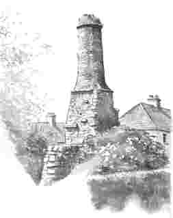
in the middle years of the 19th century. The chimney in the garden of one of
the houses in Ridgeway Road, (formerly High Street), viewed with imagination,
affords a glimpse of the old village. Old photographs show this road tree-lined
and gently curving.
Buildings inhabited long before the 20th century
may still be seen: The Court House, whose name describes one of its functions,
Lamphey House (Malthouse today), on/near the site of the Old Malthouse, Lamphey
Hall owned and occupied in the mid 19th century by George Lock who rented 'the
pleasure garden' in front from Charles Mathias.
At that time the parish had a cooper, 2 carpenters,
a tailor, 2 blacksmiths, a stonemason, a shoemaker and a master bootmaker employing
3 men (Abel Thomas). Stone was quarried for building and the extraction of lime.
Service occupations remind one of the lifestyle of the squire and of others
- owners or short term tenants of places like Northdown, Portclew, Lamphey Park,
Cleggars, Lamphey Hall (and in the neighbouring parish, Hodgeston Hall). Possibly
it was the genteel strand in the social scene which encouraged the development
of retail bakery. A Tonks baking oven, said to have been installed about 1890
by Joseph Bond at his bakery (present day Venison) was worked in addition to
a traditional brick bread oven. About 1925 R E G White converted a little stable
adjacent to the house to serve as a new bakery.
Back
to top
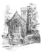
 A
puzzling feature is the name. A sign in the village points to St Faith's and
the church is so described on the 1st edition 25inches : 1 mile map published
in 1866. Samuel Lewis in his Topographical Dictionary (1833) even derived the
name of the village from the believed name of the Church - Llanffydd 'the Church
of faith'. It was thought in 1786 to be the church of St Faith. The current
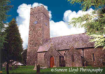
accepted designation is St Tyfai and St Faith. The building retains its medieval
plan and its fine 14th/15th century tower. Amongst fragments of early masonry
are a piscina and two lancet windows - re-set. A communion salver bearing the
name 'Lampha' has the date 1743. The Norman font is one of the best preserved
in the county.
A
puzzling feature is the name. A sign in the village points to St Faith's and
the church is so described on the 1st edition 25inches : 1 mile map published
in 1866. Samuel Lewis in his Topographical Dictionary (1833) even derived the
name of the village from the believed name of the Church - Llanffydd 'the Church
of faith'. It was thought in 1786 to be the church of St Faith. The current
accepted designation is St Tyfai and St Faith. The building retains its medieval
plan and its fine 14th/15th century tower. Amongst fragments of early masonry
are a piscina and two lancet windows - re-set. A communion salver bearing the
name 'Lampha' has the date 1743. The Norman font is one of the best preserved
in the county.
During the 19th century the living suffered
the lack of a vicarage. About 1840 the Rev. James Broff Byers lived at the house
now known as the Dial Inn, the property of Mrs Ester Phillips. In 1851 he lived
at Northdown House. The house then known as Lamphey Hall was bought for use
as a parsonage in 1895 for £600. It was afterwards altered and enlarged and
a piece of garden was given by Mr Mathias in 1896. The present vicarage was
built about 1965-6. Lamphey Hall is now a Hotel.
Back
to top
Its medieval dedication is unrecorded. Bishop
Gower is said to have been responsible for the 14th century rebuilding of the
chancel which is rather large in proportion to the rest of the church. The church
was restored in the 19th century but many original architectural features were
preserved. Adjacent to the chancel arch are the stairs of a lost rood loft.
The tower is unusually slender. The font is Norman. As in Lamphey, local limestone
is the main building material. The churches of Lamphey and Hodgeston were formerly
held in plurality and today these parishes and Carew are served by the same
vicar.The National School, established
about 1828, consisted of a school room and cottage. Charles Mathias provided
the land on a 60 year lease in exchange for another piece of land belonging
to the parish. A school until 1911, it is now a residence. A medieval carved
stone has been set into the garden wall.
Back
to top
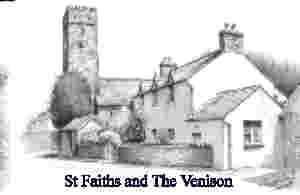
Early in the 19th century Jeremiah Thomas was
licensed to keep an alehouse and in 1826 George Mackan. Circa 1840 he was resident
at the house next to the church, believed to have been a small staging inn called
The Venison. Another local inn was The Plough (1830). The Dial (name derived
from a sundial) became an inn in 1966.
Back
to top
Built on the glebe in 1897, it was in use for
the Easter Vestry in April.
Back
to top
Acknowledements:
Text and line drawings courtesy of SPARC |
Photographs Simeon Lloyd Photography